Pear Technology – Press – Celebrating 20 years

Local Company Celebrates 20th Anniversary Milestone!

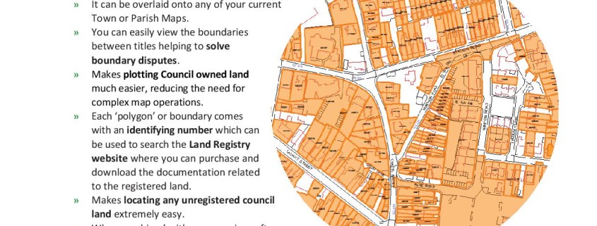
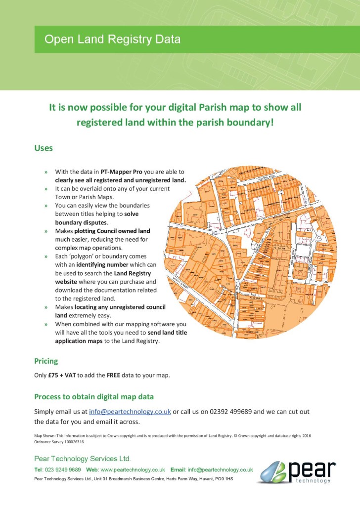
We are ecstatically proud to announce that last year Hampshire based company, Pear Technology, reached its 20th Anniversary!

Founded in 1995 by John Cowling & quickly becoming licenced partners of Ordnance Survey, the creative business has grown massively into a leading developer & supplier of digital map editing software for land management.

With an expanding customer base and 20 years of knowledge, the Pear Technology team have turned into expert consultants offering specialised software, training & a full map preparation service to get everyone going. The full shebang!

Estates, farms, arboriculturists and council’s nation-wide have enlisted the product as a core land management tool. Over the 20 years, Pear Technology has mapped nearly 2 million hectares of the UK!

To match workload the office has expanded. Holding space in Havant, the company now has more employees than ever, including whizzy placement students and postgraduates from the University of Portsmouth.

Ever growing in presence, most recently the company has seen the launch of a brand new website, www.peartechnology.co.uk. Take a look, or Tweet us @PearTechnology.

This year, with the calendar full of shows, conferences, and client meetings we are  excitedly awaiting all that is to come!

Congratulations Pear Technology, here’s to another 20 years of digital mapping action!


Reporter: Lizzy N

Council Land Titles Layer

Council Land Titles Layer

February Council News

Wednesday 3rd February.

Philippa will be at the SLCC South East Regional Roadshow on Wednesday 3rd February at the Bridgewood Manor Hotel in Chatham. Come and talk to her for a demonstration of our mapping software to see how it can help you manage your land, assets, cemeteries, allotments and more.


Thursday 25th and Friday 26th February.

Chris will be attending the 10th SLCC Practitioners’ Conference on Thursday 25th and Friday 26th February in Stratford-upon-Avon.

A special Flood Risk Management session has been included in the programme on the Thursday afternoon led by the Flood Resilience Team Leader at the Environment Agency, Kevin Barnes. Come to our stand to see the riparian boundary map Pear Technology put together for Lydney Town Council showing the land ownership around the river Lyd. Lydney Town Council’s work instigating the Lydney Flood Defence meetings helped them to win NALC Council of the Week in 2015 – http://www.nalc.gov.uk/news/entry/372-council-of-the-week-lydney-town-council


Other News.

We will be welcoming South Petherton Parish Council as a new customer. South Petherton bought our mapping software after seeing its many uses at Shepton Mallett Town Council.

If you would like a demonstration of our software please call 02392 499689. We are happy to visit your council or to connect to your PC over the internet and provide a quick one-to-one informal demonstration.

Public Rights of Way data now available for the majority of the UK

Public Rights of Way data has recently become much more widely available and Pear Technology are pleased to offer the service of adding this information to your digital map.

Available on various Ordnance Survey raster tiles, Public Rights of Way information previously had to be purchased then painstakingly traced leaving some degree of inaccuracy. It can now be added to your digital map on its own layer, making it much easier to display and edit on your map. In PT-Mapper Pro, one click can tell you how long the footpath is and another can show you the route in Google Earth’s aerial view.


Subject to the data availability, we can provide you with a layer for each classification of the Public Rights of Way. These are:

  1. Footpaths – for walking, running or mobility vehicles.
  2. Bridleways – for walking, horse riding, cycling or mobility vehicles.
  3. Restricted Byways – for any transport without a motor and mobility vehicles.
  4. Byways Open to All Traffic (BOAT) – for any kind of transport, including cars but mainly used by walkers, cyclists and horse riders.


Landowners have responsibilities for the Rights of Way which fall on their land. Knowing where these routes are is the first step in ensuring compliance with environmental law!


Did you know?

  • You are not allowed to grow crops on Public Rights of Way, although grass can be grown for hay and silage.
  • Footpaths and Bridleways may not be ploughed unless they cross fields. Landowners must then supply an access route 1m – 2m wide respectively within 14 days of ploughing.
  • You cannot put up gates or stiles without the local authorities permission.


If you would like Public Rights of Way information added to your map simply email info@peartechnology.co.uk or call us on 02392 499689 and we can check availability and provide a quote for the work.