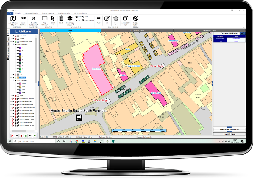
PearGIS

PearGIS

PearGIS is a powerful desktop based GIS package that offers simple mapping functionality with database driven decisions. 

Key Features:

  • Simple drawing tools for lines, points and areas
  • Add a wealth of database information to your map
  • Find information quickly by searching your data 
  • Intuitive, easy to use interface
  • Link in external databases from your network or third party software
  • Stream in data from the web (e.g. Natural England, Environment Agency etc.)

Easy to use

New and improved drawing and measuring tools

Select fields to see your information (crop, field name, area etc)

Import RPA Field Boundaries and add field margins for CSS

Easy to use ‘snap to line’ feature

Clear, modern interface helps explain the functionality of each feature

Database View & Reporting

Add data to your map layers and view this alongside your map

Search for features to easily find them on the map

Filter your data to find the information you need

Export your data to Excel to carry out further analysis

Google Earth

Open your layers in Google Earth to analyse them against aerial imagery

Trace around features in Google Earth and copy these back to your PearGIS map

Use the Google Earth timeline to view historical imagery

Filter Style

Style your map using the data you have inputted i.e. by Forestry Species (see image)

Filter styles are neatly managed within one layer on the layer list

The map style automatically responds to any changes made in the database

Stream Gov. Datasets

Stream layers into your map from websites such as Env. Agency, Natural England, British Geological Survey and more

Data from the web is kept live and current on your maps

Identify if your land is effected by any nearby environmental factors

External Data

Link your map to external data sources such as Excel, Access, SQL and more.

Seamless link with Landmark’s KeyPrime (Property Management Software)

Save on duplication by bringing in cropping data, ownership information, property data etc.

Typical Users

Farmers

Estate Managers

Land Agents

Property Management

Foresters

Arboriculturalists

Ecology

Planning

Utilities

Typical Uses

Farm Plans

Overall Estate Management

Land Agency

Property Management

Location Planning

Sales

BPS / CSS / ELMS

Natural Capital

Tenancies

Ownership

Utilities

Register to Download

    Email (required)

    Name (required)

    Organisation

    [mailpoetsignup mailpoetsignup-943 mailpoet_list_4 default:on]

    ×
    Sign up for our newsletter

    Interested in how mapping can help you? Sign up for our occasional newsletter about how people are using maps for land and asset management.

    ×
    Take a tour

    ×
    Register to Download

    Enter your details below to receive an email with download links.

    ×
    Data Sets
    ×
    Ordnance Survey Data in Pear Products

    MasterMap

    ×
    Land Registry Data in Pear Products

    ×
    Rural Payments Agency Data in Pear Products

    ×
    INSPIRE Data in Pear Products

    ×
    Register Interest

    Please enter your details below to register your interest in Map Shop.

    ×
    Register Interest

    Please enter your details below to register your interest in PearGIS. [wysija_form id=”5″]

    ×
    PearGIS Trial

    Enter your details below to receive an email with download links.

    ×
    Verified by MonsterInsights