Rural Services

Rural Services

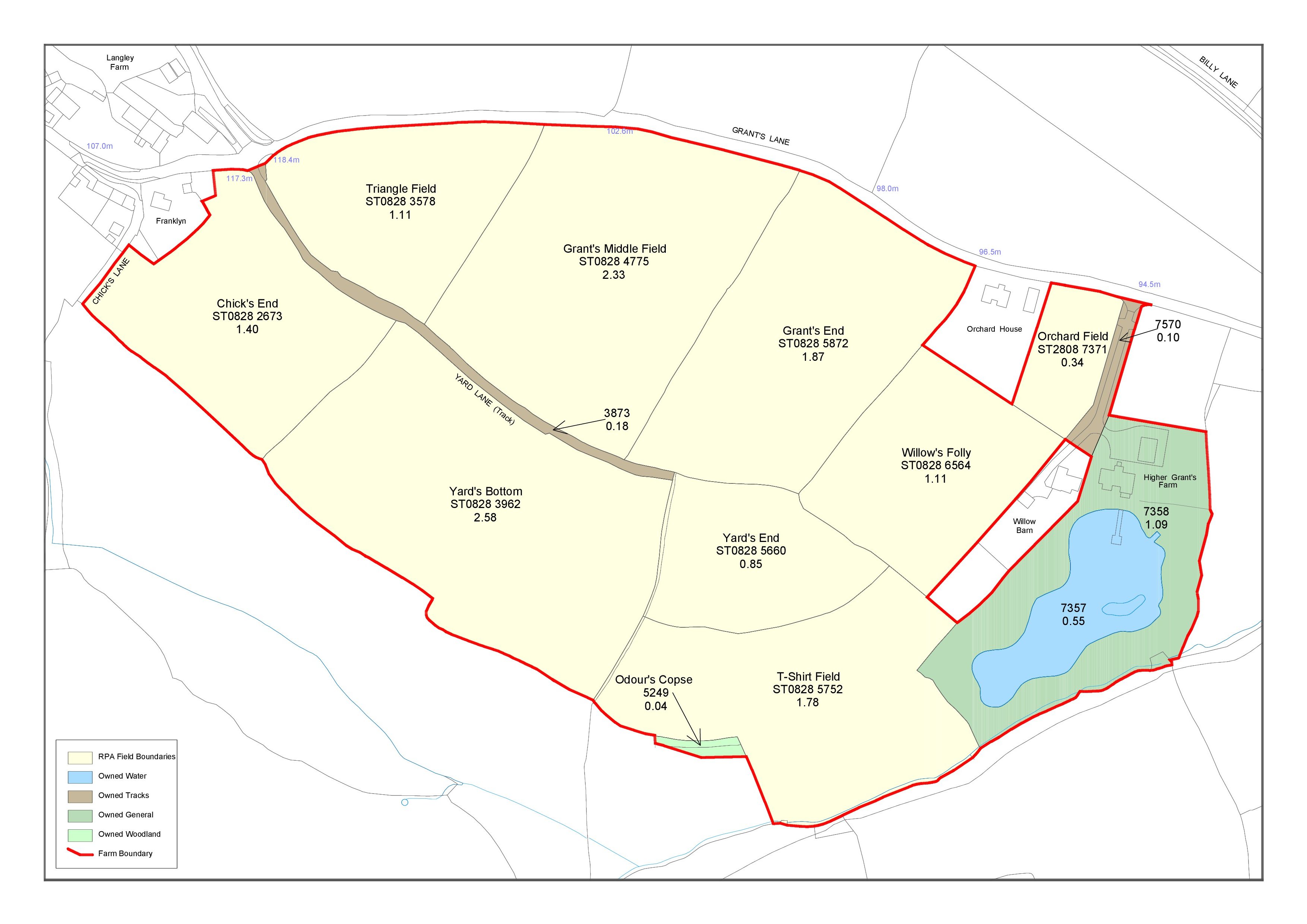
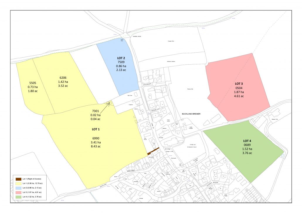
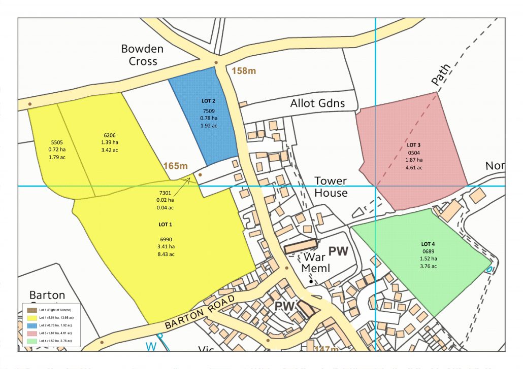
Our map preparation team can provide you with a range of maps.  From bespoke, one off plans to yearly basic payment scheme maps, just ask! All we need from you is a simple outline of the area in question, be it a scan of an existing plan, a redline in Google Earth or a digital mapping file such as a shapefile.

What do we offer?

Pear Technology’s in house map preparation team are able to produce a wide range of maps to suit your requirements. This can range from the typical uses shown to the right or might entail more bespoke requirements.

All we need is a plan from you to help us identify the land in question. This can be emailed through to info@peartechnology.co.uk along with a description of what you would like mapping.

A standard setup might include mapping a farm or estate boundary then splitting everything within this into land classification layers such as fields, woodland, tracks etc. Or you might like RPA boundaries, lots, tenancies etc. to be mapped.

Typical Uses

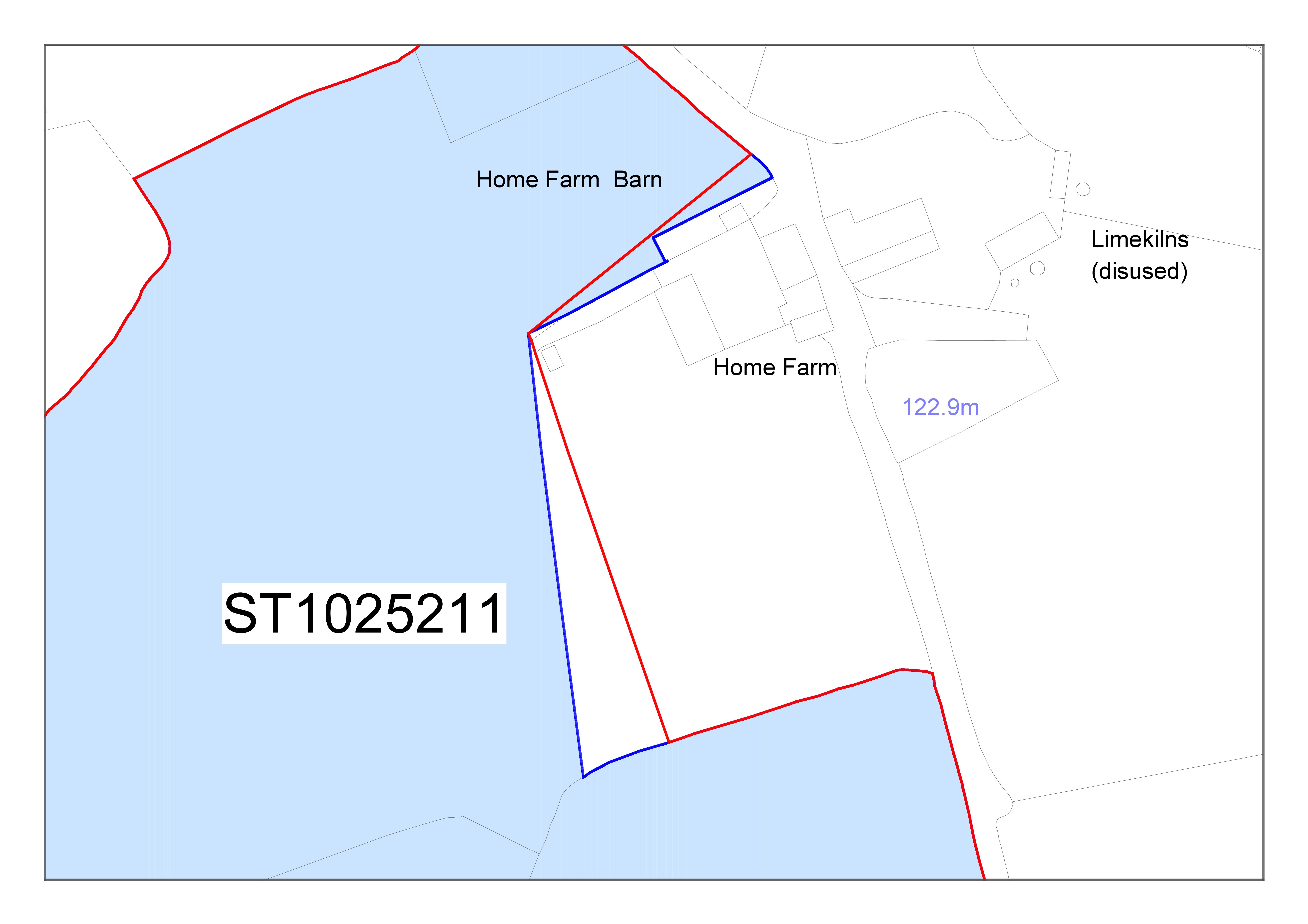
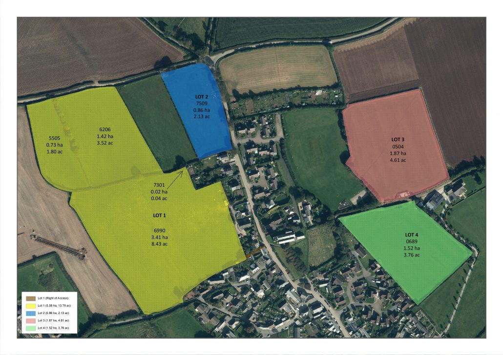
  • Land Registry Compliant Plans
  • RPA / BPS
  • Sales Plans
  • Tenancies
  • Ownerships
  • Forestry
  • Lots
  • CSS / HLS / ELS
  • Shoot Maps
  • Cropping

Why do I need a Map?

Today, maps are more important than ever. Government Agencies such as the Land Registry, RPA, Forestry Commission and more all require maps to accurately identify parcels of land.

Using either our software or our in-house map preparation service, you are able to produce professional, compliant plans.

Not only are maps useful for official documentation, but for everyday management of farms and estates. Having a centralised system to record knowledge such as utilities, that might just be in one persons head, is an invaluable tool to have.

Government Data

Ordnance Survey Data – It’s Your Choice

Pear Technology - OS Partner

The Software

Our PT-Mapper software allows you to easily create plans by editing the Ordnance Survey data you have as a backdrop. Simply shade or outline areas to customise your map.

Our software is quick and easy to use, but if you are running short on time, please contact us to use our map preparation service.

Pear Map Shop

If you are happy creating plans yourself, the Pear Map Shop gives you instant access to the latest Ordnance Survey MasterMap and Vector Map Local data.

Simply draw the area of land you require, calculate an instant price and download directly into PT-Mapper once happy.

To request access, please use the ‘Register Interest’ button on the Pear Map Shop page.

Prints

GPS Hire

We offer prints ranging from A4 up to A0 that can be posted in a rolled tube to protect your prints.

We also offer whiteboard prints (as seen above) that are great for the office wall. They are also very practical for pre-shoot meetings for example, to explain and share the plan for the day.

If you have an existing plan, email us a copy of your map and we can provide you with a quote. Otherwise please tell us what type of map you would like to be produced and printed.

We offer a range of GPS devices for you to hire in order to capture information about your land. This might include new field boundaries, trees, utilities, fence posts, hedges, field margins, hydrants, drainage etc.

The data is simply exported from the device and imported straight onto your map.

The devices we offer range in accuracy from 1 to 2 metres, all the way down to 5cm accuracy

Contact Us

Register to Download

    Email (required)

    Name (required)

    Organisation

    [mailpoetsignup mailpoetsignup-943 mailpoet_list_4 default:on]

    ×
    Sign up for our newsletter

    Interested in how mapping can help you? Sign up for our occasional newsletter about how people are using maps for land and asset management.

    ×
    Take a tour

    ×
    Register to Download

    Enter your details below to receive an email with download links.

    ×
    Data Sets
    ×
    Ordnance Survey Data in Pear Products

    MasterMap

    ×
    Land Registry Data in Pear Products

    ×
    Rural Payments Agency Data in Pear Products

    ×
    INSPIRE Data in Pear Products

    ×
    Register Interest

    Please enter your details below to register your interest in Map Shop.

    ×
    Register Interest

    Please enter your details below to register your interest in PearGIS. [wysija_form id=”5″]

    ×
    PearGIS Trial

    Enter your details below to receive an email with download links.

    ×
    Verified by MonsterInsights