
https://www.peartechnology.co.uk/wp-content/uploads/2014/07/a-guide-to-the-basic-payment-sch.jpg
720
1280
Roger Marsh
http://www.peartechnology.co.uk/wp-content/uploads/2013/04/Pear-340x156-v2-e1499887032605-300x113.png
Roger Marsh2014-07-12 20:08:532020-08-13 15:09:40A guide to the Basic Payment Scheme
Archive for month: July, 2014

The CLA Game Fair – 18-20 July 2014


What a great show the CLA Game Fair was. It was wonderful to meet so many new people and see so many existing customers. With all our new digital mapping options for estate and farm mapping there was a lot to talk about. The Basic Payment Scheme mapping was a hot topic and there is more to come on that front. Get in touch with Pear if there is anything more you would like to know.
 Win a tablet
We are developing some great new ideas that utilise mobile technology to ensure you always have the right information wherever you are. To help you get the full picture we’ll be giving away a Galaxy Tab II smart tablet. Just enter your details below to enter the draw.
Error: Contact form not found.
Free Rural Payment Agency maps for digital mapping
Please note this article was written in 2014. You can find the latest way to download your RPA field boundaries by clicking on our new post here.
See note above. Click here for latest info.
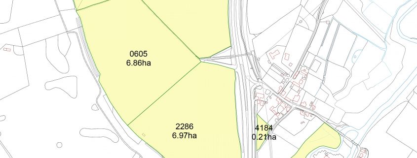
Having Rural Payment Agency maps in digital format has many benefits to the landowner. Here’s how to get hold of them.
There are many advantages of having your RPA maps in digital map format within PT-Mapper compared to a simple PDF. In PT-Mapper you can select any map features to get measurements of area or length. It is also possible to make additional edits such as adding buffer strips, or splitting fields. By working with the data sourced from the RPA you can work with the certainty that you are operating with the approved data for your land. PT-Mapper will display the RPA field boundaries onto your existing maps with the field numbers and areas as specified by the RPA. You will then be able to treat them as you can anything else in PT-Mapper. Follow the steps outlined below to import them into the latest version of PT-Mapper.
How to obtain your maps
By Email
- Have ready your Business name and SBI number
- Email: csc@rpa.gsi.gov.uk and ask for the ‘shapefile’ of the RPA field boundaries for your Business name and SBI number. Request for the shapefile to be returned to your email address.
By Phone
- Have ready your SBI number & Business name to give to the operator
- Call: 03456 037777
- Choose the 5th option ‘Land and Mapping’
- Go through any security chekcs
- Asked to be emailed the ‘shapefiles’ RPA field boundaries, give the email address held on the RPA system for them to return the data to.
Importing the digital Map file into PTM
- Save the file returned from the RPA to an appropriate place on your computer, and ‘unzip’ the folder
- Within PT Mapper click – File> Import> Import RPA file
- Find the RPA file you have unzipped and click Open
- Your RPA Map should now be imported onto PT Mapper. If not, please contact us.
Pear Technology at the National Amenity Conference
Pear Technology will be attending the Arboricultural Association’s National Amenity Conference on the 15-16 September 2014 at Royal Holloway, University of London. For more information about the conference, click here.

Pear Technology at APF 2014
Pear Technology will be attending APF2014 – the UK’s largest forestry, woodland and arboricultural exhibition at the Ragley Estate, Alcester on 18-20 September 2014.
The introduction of the Basic Payment Scheme (BPS)
The new CAP Reform for farmers will be replacing the Single Payment Scheme in 2015 with the introduction of the Basic Payment Scheme. Get prepared by organising your maps quickly and easily with Pear Technology.
Pear’s rural land management mapping software, PT-Mapper, allows you to cover all the forthcoming requirements, including:
Greening
As a farmer, you will need to comply with three “greening measures”. These three measures will affect up to 30% of the BPS payment, so it is important to ensure you are compliant with the requirements. Additional EFA options may be added in time, but initially the three areas are:
Ecological Focus Areas
Buffer strips and hedges count as high importance EFAs and are weighted highly. However, farmers deciding to use hedgerows as part of their EFA could face a significant delay to their payment because of the mapping requirements. It is therefore important to submit suitably mapped claims as soon as possible.
Crop diversification
Environmentally beneficial crops, such as nitrogen fixing, catch crops and cover crops are included. There will be no restrictions on inputs (pesticides and fertilisers). The list of crops counting towards this requirement is to be published shortly.
Maintenance of permanent grassland
This relates to land lying fallow where you have sown with environmental seed mixes such as wild bird seed mix and pollen and nectar mixes.
Weightings and coefficients
These weightings will affect how much each option will count for on the ground:
| Features | Conversion factor | Weighting factor | Ecological focus area |
| Buffer strips | 6 | 1.5 | 9m² |
| Hedges | 5 | 2 | 10m² |
| Catch crops/green cover | n.a | 0.3 | 0.3m² |
| Nitrogen fixing crops | n.a | 0.7 | 0.7m² |
| Land lying fallow | n.a | 1 | 1m² |
For example hedgerows 100m will be multiplied by a conversion factor of 5, and the weighting factor of 2 Result= 100 x 5 x 2= 1000m2 Please see additional documentation on information relating to double funding and decisions regarding GAEC standards.
*Document referenced from the CLA documentation
For more information, please visit:
Gov.uk- Countryside gets set to claim £15billion under CAP reform NFU- Basic Payment Scheme – BPS CLA- BASIC PAYMENT SCHEME Robinson and Hall- CAP Reform 2015 – The New Basic Payment Scheme

See the video on how to map your BPS options and calculate the Ecological Focus Areas here


