We’re excited to announce that on 1st July 2025 Pear will be moving to a fantastic new office location at Gatcombe House, Copnor Road, Hilsea, Portsmouth, PO3 5EJ! This move marks an exciting new chapter for us, providing a larger and more modern space.
The move itself will take place over the next week from 23rd June, and while we’re working hard to make the transition as smooth as possible, we apologise for any potential disruption to our technical support service during this period.
If you find it difficult to get through to us by phone over the next week, please don’t hesitate to email us, and we’ll be sure to return your call as soon as we can. We appreciate your patience and understanding.
Important Information for Map Amendments
For anyone with outstanding map amendments, please take note of our new address at
Pear Technology Services Ltd
Gatcombe House
Copnor Road
Hilsea
Portsmouth
PO3 5EJ
We kindly ask that you check our updated address before returning any maps to us to ensure they reach us safely.
https://www.peartechnology.co.uk/wp-content/uploads/2025/06/Pear-Moving.png512512Holly Parfoothttp://www.peartechnology.co.uk/wp-content/uploads/2013/04/Pear-340x156-v2-e1499887032605-300x113.pngHolly Parfoot2025-06-20 14:33:532025-06-20 14:51:43Pear are moving
Great news! We’ve just added new council and cemetery case studies to the Pear Technology website, showcasing how our mapping solutions are making a real difference for our clients.
Discover How Pear Technology is Empowering Local Councils These new case studies offer a fascinating look at the diverse ways Pear Technology’s expertise and PearGIS software are being used to solve real-world challenges for local councils.
Chippenham Neighbourhood Plan: Read how our mapping services and solutions are invaluable to town planning and community development.
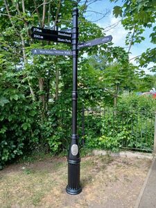
Ross-on-Wye Wayfinding Measurements: Learn how we helped modernise town centre signage by providing precise wayfinding measurements using our new PearGIS software.
Henley-on-Thames Cemetery Management: Discover how an interactive online map revolutionised cemetery and burial record management for the council.
These stories highlight our commitment to providing tailored, effective mapping solutions. We invite you to explore these new case studies and see the tangible benefits our clients are experiencing.
Been inspired to take on a mapping project of your own? Has your council used Pear’s mapping software to help revolutionise grounds management or events? We’d love to hear from you – get in touch today!
Chippenham Neighbourhood Plan Case Study
Ross-on-Wye Town Council Fingerpost Wayfinding Measurements Case Study
https://www.peartechnology.co.uk/wp-content/uploads/2025/06/new-case-studies.png300300Holly Parfoothttp://www.peartechnology.co.uk/wp-content/uploads/2013/04/Pear-340x156-v2-e1499887032605-300x113.pngHolly Parfoot2025-06-13 14:27:182025-06-13 14:41:12New Council Case Studies
We are excited to announce that Pear Technology will be attending Cereals at Heath Farm, Leadenham, Lincs LN5 0QE on 11-12 June.
Cereals is the UK’s flagship arable event with over 420 leading suppliers showcasing the latest innovations, products and expert advice.
We’ll be demonstrating the latest PearGIS software developments, OTISS, and GNSS surveying hardware and our team will be available to discuss how our solutions and services can help your business.
If you are attending, stop by and see us on stand 218 in the Business, Innovation, Energy & Diversification zone.
Entrance to the show costs just £15 if tickets are purchased online by June 11th; or are available on site for £20 11/12 June.
Shows and conferences are a fantastic opportunity to see our software in action and ask questions. Try out our range of GPS handheld equipment and learn more about how mapping software can improve your businesses efficiency.
We look forward to seeing you this year!
https://www.peartechnology.co.uk/wp-content/uploads/2024/09/Pear-Calendar.png700700Holly Parfoothttp://www.peartechnology.co.uk/wp-content/uploads/2013/04/Pear-340x156-v2-e1499887032605-300x113.pngHolly Parfoot2025-02-11 16:06:072025-06-13 14:31:54Upcoming Events in 2025
https://www.peartechnology.co.uk/wp-content/uploads/2024/10/FBI-Pear-2024-1.jpg344558Holly Parfoothttp://www.peartechnology.co.uk/wp-content/uploads/2013/04/Pear-340x156-v2-e1499887032605-300x113.pngHolly Parfoot2024-10-29 15:42:102024-10-30 10:52:59Farm Business and Innovation 2024