

Interactive town and parish maps
Mapping software with In Person Training
Custom Map Preparation
Asset Plotting
Plotting and managing your Council’s Land and Assets

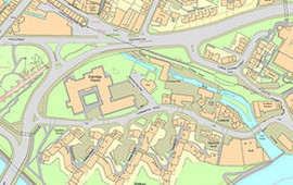
Our map editing software, PearGIS, enables you to identify your council owned land and buildings, highlight your parish and ward boundaries and add your own information to the map of your parish. Information from outside sources can also be incorporated into your map such as Land Registry Titles and map data from your Higher Authority. This data can include information on Tree Protection Orders (TPO’s), Listed Buildings, as well as access and maintenance issues. Digital mapping becomes an invaluable tool when considering land and asset transfers from your Higher Authority.

Pear can create an interactive map of your cemetery using your old paper cemetery maps (and other sources) that can be easily updated and amended using our PT-Mapper Pro software or via our Map Maintenance service. The map can be linked locally to your burial records using either our MapLink software, or set up online via our Cemetery Searcher package. Maps can also be linked to your existing burial administration system such as Epitaph (HeritEDGE), BACAS or Rialtas Cemeteries.
Find out more on our Cemetery Services page to see how it’s done and read our various case studies, including how Henley-on Thames Town Council opted for an aerial imagery based map.

Our map editing software PearGIS allows you to create maps to help you plan and organise your public events. Click on stalls to see the stall holder information. Sections of your town map can be “cut out” and edited to plan Carnival routes, Food Festivals, Christmas lights, bonfire and firework displays, street markets and processions etc. Once the map has been created it can be displayed on your website, included within a brochure and displayed on notice boards. Communication with the public, the emergency services, the environmental health authority etc, becomes more professional and efficient with the aid of digital mapping.

Data relating to condition surveys for assets and trees can be collected whilst out in the field. Pear Technology offer two methods of capturing data remotely. The first method involves the use of an android device with a surveying software programme, Pocket GIS.
The second method using our OTISS technology enables survey data to be captured in the field, also using an android device, and uploaded to OTISS website. Tree data can be exported from OTISS and imported into PearGIS.
The task of preparing a neighbourhood plan can be simplified using our GIS software, PearGIS. Maps can to be prepared highlighting the areas associated with the neighbourhood plan which can then be used for communication with the public. Maps can also be prepared to include information on local amenities, footpaths, bridleways, areas of interest and scenic beauty. The maps can be printed on paper, sent to a printer for publication and displayed on your website.
Read our Case Study explaining how Pear produced the maps for the Chippenham Neighbourhood Plan here.
 Our map editing software, PearGIS enables you to create maps outlining the procedures that would be implemented in the event of an emergency. Buildings can be highlighted for use as emergency shelters and alternative routes can be highlighted in the event of flooding and road closures. Risk assessments can be carried out and the individual record can be linked to the relevant feature. The start of the journey towards a paperless office!

Managing the layout of your recreational facilities is made easy with the use of our map editing software PearGIS. Sports pitches can be laid out on the map utilising the available space. Each type of pitch can be drawn to scale and it’s position adjusted to maximise the use of the space. Seating plans for public halls can be drawn up and the various arrangements can be displayed on your website saving you time when dealing with enquiries from the public.
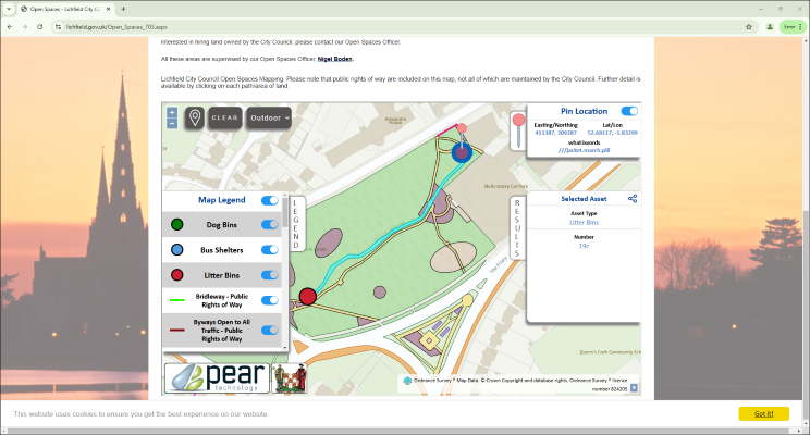
Display your town’s assets and land in the public domain, with an interactive format.
Allow the public to easily see whether land or assets are Council owned.
Save Council staff time by providing an interface where the public can easily see the location of Council owned assets and land.
Our interactive digital maps allow the public to see who owns and maintains the asset, as well as maintenance schedules and other key asset info. Council staff and groundsmen can simply check via mobile phones what has to be done when on site, so everyone is on the same page.
For full details, click the link below:
https://www.peartechnology.co.uk/councils/council-asset-plotting/
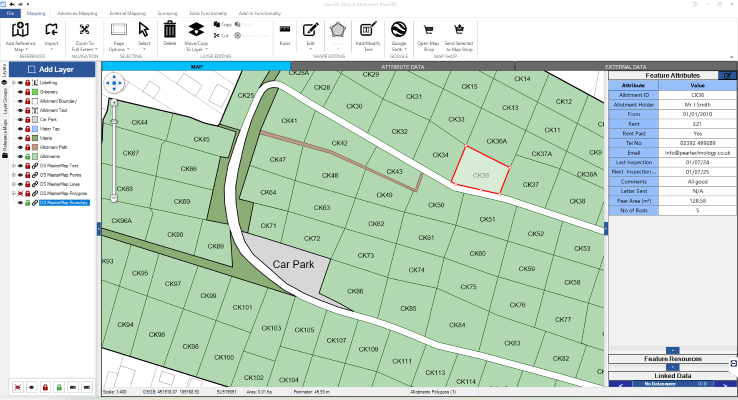
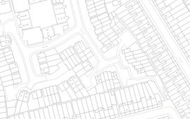
Digital copies of your existing allotment garden plans can be created using our PearGIS software. Once the maps have been created it is then possible to add or link each allotment plot to the data associated with it, either adding data to the map or by linking an external spreadsheet or database. Allotment tenancy agreements can now be produced quickly and easily and include an accurate map of the plot.
Monk Hesleden Parish Council has used Pear Technology’s Mapping Software for several years and has found it to be an invaluable tool. The software enables us to produce maps needed for projects, maintenance, recording assets and we have Cemetery Searcher, which is linked to our website and provides members of the public to search for family graves.
We mostly use PT-Mapper Pro for asset mapping. I have not only found it easy to use but also very useful as the data is linked to each asset which obviously saves us time. I haven’t had any difficulties with the software but any technical issue I have had, I just call up and it gets sorted asap!
It’s difficult to quantify monetary savings but the system has enabled us to do our work in a faster, more professional and more responsive way. It’s difficult now to imagine not having such a system.
All three of the council’s cemeteries required mapping as part of the digitisation project. The mapping process is very straightforward and Pear were extremely professional and helpful. Having the burial records and details of all our cemeteries at my fingertips has been well worth the cost and effort involved and will prevent any mistakes being made in future.
We now have an accurate map and confidence that the graves are correctly located. Support and communication from Pear were excellent.
The council needed a one-off map showing public rights of way, bus stops and permitted routes across council land for our website. We’re very pleased with the clear and accurate map Pear provided and also the quick turnaround.
The support provided by Pear is first class, especially for those of us who are less confident with technology!