Great news! We’ve just added new council and cemetery case studies to the Pear Technology website, showcasing how our mapping solutions are making a real difference for our clients.
Discover How Pear Technology is Empowering Local Councils These new case studies offer a fascinating look at the diverse ways Pear Technology’s expertise and PearGIS software are being used to solve real-world challenges for local councils.
Chippenham Neighbourhood Plan: Read how our mapping services and solutions are invaluable to town planning and community development.
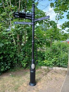
Ross-on-Wye Wayfinding Measurements: Learn how we helped modernise town centre signage by providing precise wayfinding measurements using our new PearGIS software.
Henley-on-Thames Cemetery Management: Discover how an interactive online map revolutionised cemetery and burial record management for the council.
These stories highlight our commitment to providing tailored, effective mapping solutions. We invite you to explore these new case studies and see the tangible benefits our clients are experiencing.
Been inspired to take on a mapping project of your own? Has your council used Pear’s mapping software to help revolutionise grounds management or events? We’d love to hear from you – get in touch today!
Chippenham Neighbourhood Plan Case Study
Ross-on-Wye Town Council Fingerpost Wayfinding Measurements Case Study
https://www.peartechnology.co.uk/wp-content/uploads/2025/06/new-case-studies.png300300Holly Parfoothttp://www.peartechnology.co.uk/wp-content/uploads/2013/04/Pear-340x156-v2-e1499887032605-300x113.pngHolly Parfoot2025-06-13 14:27:182025-06-13 14:41:12New Council Case Studies


 Pear are moving


